
Resources
Take a look around
Zoning
Zoning and land use principles in the community will (drive) the project in any given location. It is critical that you understand what uses and structures are permitted at a potential development site by contacting local officials early in the development process and becoming familiar with the community’s zoning ordinance. It is highly recommended that the local municipality is engaged early in the development process.
Zoning regulates the long-term use of land, while a master (or comprehensive) plan defines a community’s goals and further refines them with a framework of objectives and strategies. Not all communities have zoning ordinances, but for those that do, the zoning ordinance is intended to be based on its master plan (sometimes called a “comprehensive plan”).
Both the zoning ordinance and master plan exist within a legal framework. The master plan provides the rational basis for the regulation and is granted authority through the Michigan Planning Enabling Act, while the zoning ordinance defines the land use regulations in various “districts” and is granted authority through the Michigan Zoning Enabling Act (MZEA).
WUPPDR’s Resources for Housing Developers webpage includes a list of key documents, contacts, and utilities information for every municipality in the Western U.P., including direct links to master plans for communities that have one available.
Along with a master plan, many communities are providing development guides that are tailored to their unique local context, with the aim of making the process as easy as possible. For example, Redevelopment Ready Communities (RRC) are expected to have a development guide readily available online. These resources help in understanding a community’s policies and identify opportunities that fit within their broader planning framework.
Zoning
Zoning regulates how land can be used and developed, including what types of buildings are allowed, their placement, and their size. Zoning ordinances are legally enforceable and carry penalties for violations. (If zoning provisions are violated or ignored, it is possible for a jurisdiction to require an improperly built structure to be modified or even demolished.) Zoning ordinances are based on a community’s master plan that provides the foundation and rationale for zoning decisions, ensuring that regulations support the community’s goals for growth, preservation, and public welfare.
One of the key elements of a zoning ordinance is the establishment of zoning districts. Zoning districts separate land uses into broad categories. Each municipality can create their own distinct districts, following the Michigan Zoning Enabling Act (MZEA) that allows much flexibility in how these are defined. Descriptions of each district should include permitted uses; the form, spacing, lot coverage, and size ranges of buildings; and sometimes minimum and/or maximum parcel sizes.
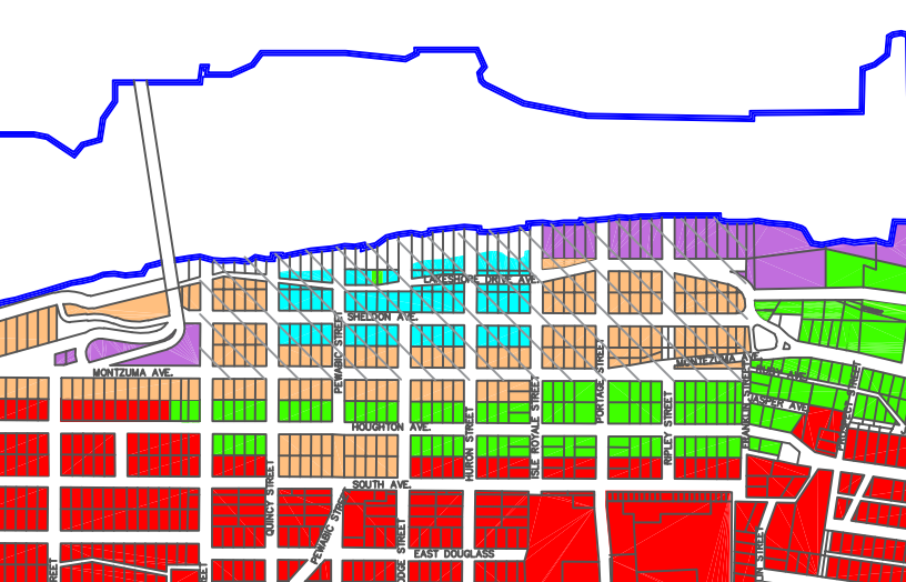
Communities can also create an additional district that is laid over two or more other zoning districts, known as an overlay district. An overlay district may have different or additional regulations that apply to the area of the overlay. For example, the City of Houghton zoning map features a central business overlay district which is laid over portions of four other zoning districts; the overlay district is intended to preserve the historic character of Houghton’s downtown and promote a thriving, walkable and bikeable city center, among other priorities (Figure 3).
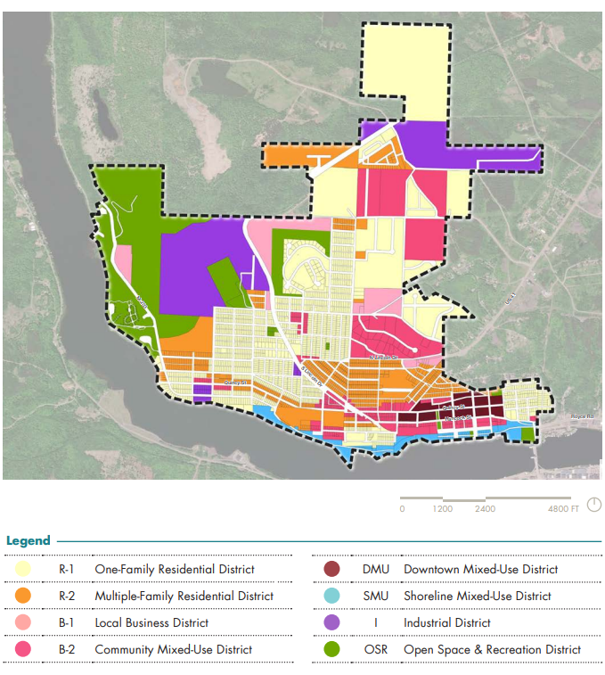
The zoning ordinance is accompanied by an official zoning map that displays land uses allowable throughout the community (single- and multiple-family residential, commercial, industrial, etc.) (See Figure 2 for an example.) Whereas a zoning ordinance shows current allowable land uses, a future land use map, which is part of the master plan, shows long-term objectives for types of development throughout the community. It is important to be aware, early in the development process, of how a potential housing project aligns with the future land use and zoning maps. Conflicts can slow or prevent regulatory approvals and/or can hamper community acceptance of a project.
A zoning ordinance typically contains the following elements (however, there is variation):
Purpose
Definitions
General provisions
Specific use standards
Zoning map
Explanation of zoning districts
Nonconformities
Permit information
Special uses
Planned unit developments
Site Plans
Zoning administrator
Appeals board
Penalties
Amendment and variance processes
Typical zoning districts include:
Residential
Commercial
Mixed use
Rural residential
Industrial
Office
Public land
Natural areas, conservancy land, or recreational areas
Working lands: agricultural, forestry, mining
Some zoning ordinances also define rules for planned unit developments (PUDs). A PUD is a flexible zoning mechanism that allows for different land uses within a defined area. An area that is rezoned as a PUD can have multiple land uses within it. For example: housing, recreation, and commercial areas within one subdivision would require a PUD. PUDs can be attractive to communities because they can allow for higher density housing and preservation of green space. As more communities and residents desire walkable, thriving community centers, developers are in a great position to use PUDs to meet demand and ensure successful projects.
Nonconformities
A property may have an existing use, structure, or other site characteristic that does not comply with zoning requirements because it existed before zoning or a zoning amendment was adopted, or due to other governmental actions. An example might be the creation of a new road. These are called nonconformities. Be aware of any nonconformities in sites considered for development and the rules related to nonconformities in the community’s zoning ordinance.
The act of purchasing a property without understanding its zoning limitations is not adequate grounds, on its own, for a variance to be granted (this would be considered a “self-created” hardship). Check the community’s zoning ordinance to determine how to apply for a variance. Typically, the appeal will require a description of the property and of the variance requested; a statement of demonstrated need, including why the need is not self-created; a drawing of the property; and other pertinent information. The appeal will be considered by the body designated in the zoning ordinance (typically a zoning board of appeals) during a public hearing, when they determine if the variance is necessary based on a finding of fact and will either grant or deny the variance.
Variances
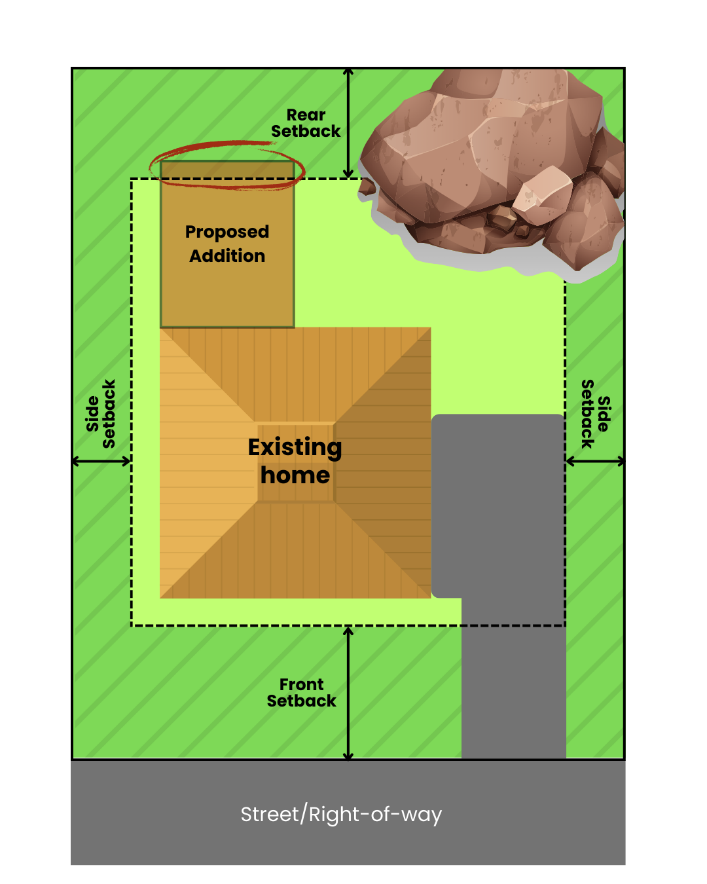
When development is impeded by existing zoning an appropriate remedy to allow flexibility is a variance. A variance allows for an exemption from a particular requirement of the zoning ordinance because of characteristics unique to a specific lot/parcel. For example but due to the characteristics of the land, the only suitable location for an addition would make the structure encroach upon the required setbacks.
Amendments
There are times when a development may be beneficial to the community, harmonious with surrounding neighborhoods, and consistent with the master plan, but is difficult or impossible to undertake due to provisions of the zoning ordinance. In such cases, it is possible to request an amendment to either the text or map of the zoning ordinance. Amendments are the most appropriate remedy for impediments or opportunities that apply to a large area or the entire community rather than just a single parcel. An amendment can only be made by the governing body (e.g. city council). A zoning administrator should generally be able to tell an applicant when an amendment would be required to undertake a development.